[The following statement is of unknown origin but was probably prepared by a local community group for submission to the committee which prepared the 1946 Parliamentary report.]
Much has been written about the development of the port of Coff’s Harbour. When John Korff sailed into what is now known as Coff’s Harbour, he didn’t think for one moment that he was opening up for development a new port, which was to grow rapidly in importance until it held pride of place over most other ports on the Northern Coast of NSW.
To trace its rise and development, from the time of that one lonely ship sheltering from the cruel and bitter winds, together with a storm tossed sea, to the present day, we must go back one hundred years to the year 1850, the year in which the port was first discovered by Korff.
Korff realised the potentialities of the fine stretch of water, which he named Korff’s Creek, and also the very splendid natural bay which Mother Nature had so generously placed in close proximity to the outlet to the creek. He used both the creek and the harbour as a refuge for his ships during any rough weather. The Creek was at that time a very wide and deeply flowing stream and boats could traverse its length for a great distance.
It has been stated on some occasions that a little later Korff built a rough shack on the water frontage and began to draw upon the huge supplies of timber, including the famous red cedars which were growing in abundance nearby and which he exported to Sydney and other centres. This, of course, has never been proved beyond any doubt. John Korff regarded the harbour as his own and maintained its upkeep for twenty years until his death in 1870, and later Walter Harvie took up residence and began life as a cedar-getter in 1870.
With the settlement of many settlers from 1880 onwards the cutting down of timber increased greatly and the vast quantities of timber being sent away from the port mounted as each month slipped by and the settlement continued to grow. The loading facilities in those days at the port of Coff’s Harbour were very crude indeed compared to modern methods and standards.
During the years 1880 to 1890 the various sailing ships which came to Korff’s Harbour anchored behind Coff’s Island and the island now known as Mutton Bird Island. However, despite this wonderful anchorage and comparatively safe, calm water, there was great inconvenience as far as the loading and unloading of timber and other goods were concerned. The wagons carrying the giant logs were unloaded on to the beach, to be washed
out to sea by the outgoing tide, or to be dragged out by bullocks or men in boats. Once out over the silvery breakers, trained and experienced workmen dragged the logs behind boats out to the awaiting vessel, which was anchored out in the harbour in deeper water. Here the sailors and other workmen would manoeuvre the logs into positions and the ship’s cranes would lift them on to the boat where they would be neatly stacked, either in the hold or on the deck. This method of loading continued for many years until the need was felt for the construction of a jetty in order to facilitate the loading of timber.
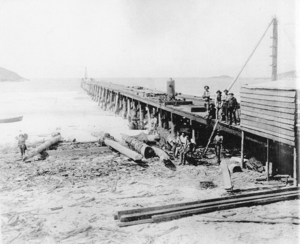
Thus, in the year 1890, after much consultation among the leaders of the town and Government at the time, the construction of the Jetty began. This year was one of the most important years in the early history of the port and the village of Brelsford. Mr Thomas Dawson, a builder and contractor, arrived at the port in 1890, his special mission being the erection of a suitable jetty.
A vast collection of piles and mber had been assembled in readiness for the work, and this had all been obtained locally and sawn in readiness at the sawmill owned by John Mills, the district’s first sawmiller, at a spot nearby where the Vacuum Oil Company’s depot now stands. The first pile in the construction work on the Jetty was driven by Alfred L. Walsh, a contractor, who arrived about the same year.
During the next three years until 1893, work continued unceasingly (except for bad weather) until the jetty extended from the shore 1,080 feet out into the harbour towards the southern tip of Mutton Bird Island. While the construction of the jetty was in progress a ship called the “Byron” called at the uncompleted jetty to take on a cargo of sugar from Alexander Herman’s sugar mill at Korora. The Captain of this vessel to call at the jetty was Captain Hunter, and as the vessel stood only a few feet out of the water, the sugar was taken to the end of the jetty by means of Mr Lawson’s trucks which he kindly lent for the occasion. From there the sugar was loaded into the “Byron” by means of shutes, which were placed in position from the framework.
Disaster was associated with the building of the jetty on more than one occasion and the work was not finished without a few disappointments. One particularly violent and severe storm struck the harbour during the construction of the jetty and destroyed six complete bays, which took much extra work to repair and replace so that the work could continue.
After the construction of the jetty was completed in 1893, the need was felt for some protection to the jetty and foreshores by the building of stone walls or breakwaters. Many prominent people put forward different proposals to develop a safe storm free port or harbour for large vessels which would be using the port in years to come. Considerable interest was taken in the Government’s proposal to construct a large northern breakwater from the beach, near the entrance to Coff’s Harbour Creek, out to sea until it was joined to the rocky shores of Mutton Bird Island. Also it was proposed to additionally construct a southern breakwater from the headland on South Coff Island, on the southern side of the port, out to sea towards Mutton Bird Island, leaving a gap of only 1,000 feet for an opening, through which vessels could safely pass into the harbour and so to the jetty. The northern breakwater would satisfactorily shut off the port from all possibility of rough disturbances from the rough seas which would come from the north and north-east. The southern wall would similarly protect the southern and south-east side of the port from any heavy seas coming from this direction.
Eventually, after much agitaon and delay, work began on this tremendous undertaking in the year 1912 and has continued ever since, except for minor stoppages during war years. The breakwaters are continually being added to and made higher, wider, stronger and more able to hold back the swells and tremendous waves of the northeasterly and southerly gales.
The original plan for the construction of the harbour allowed for the construction of two jetties, each 650 feet long and 80 feet wide, under the lee of the Southern Headland. As the work progressed, however, this suggestion was dropped in favour of concrete wharves which would be constructed along the northern side of the harbour.
At present the type of wharf is doubtful as the harbour is still much affected by the east to north-easterly roll which sweeps into its mouth.
During the construction of the breakwater various other centres on the North Coast advanced claims for the construction of deep-sea ports, but the people of Coffs’s Harbour did not stand in the back ground. They had their leading citizens, deputations and engineers working towards their desired goal, the realisation of a deep sea port for the town.
Mr E.M. de Burgh, the engineer for Harbour and Water Supply of 1912, had drafted a plan for the port at Coff’s Harbour, with a depth of forty feet of water. This was estimated at the time to cost approximately £439,000. In
addition de Burgh gave alternative plans which were more extensive and costly. He considered that his first plan would ideally suit the trade demands of the town supported by the surrounding areas of the North Coast and Tablelands.
The Commission which had been established to look into the deep sea port and the decentralisation of the northern part of the State turned down de Burgh’s proposal as they had already decided upon Port Stephens as their site for the deep sea port. Both the people and the officers drawing up the proposals knew that Coff’s Harbour, which occupied a central position on the coastline, was the most accessible point to the whole of the interior of Northern New South Wales. The prepared plans were in every way ideal, and they knew that it would not be long before Coff’s Harbour was eventually chosen also as a site for a deep-sea port. They also knew that if the north was to be decentralised, then the logical outlet was Coff’s Harbour, as the decision in respect to Port Stephens as a decentralisation point was entirely erroneous.
Agitation continued and in 1913 a proposed scheme for the improvement of facilities at Coff’s Harbour for coastal trade was referred to the Public Works Committee. This committee favourably recommended this to the Government of the time, with the result that the works already mentioned were commenced and have continued over the years to the present time.
The Government’s plan at first was to achieve a port that would serve some 1,600 square miles of country. But as the works progressed, the plans were so modified as to allow an enclosure of a greater area of water, and to provide for the berthing of a greater number of ships. This smaller scheme was not to hinder the development of a deep-sea port but to actually form portion of the works which would in time go to make up the final scheme of the deep-sea port.
In 1925, on the 30th May, Sir George Buchanan, an important and authoritative English harbour and harbour construction engineer, visited Coff’s Harbour on his trip to the North Coast. He inspected the port and the breakwaters which had been completed at the me. (The northern wall had been carried out to Mutton Bird Island for a distance totalling 3,288 feet – almost five-eighths of a mile in length – but very little progress had been made on the eastern or southern wall.) Buchanan that day met a deputation of responsible citizens of the Coff’s Harbour Chamber of Commerce and told them many interesting points about their harbour and proposals. He said he had “never seen a place so admirably adapted for the making of an artificial port and that the aspirations of the people for a port were most reasonable and legitimate”.
After the completion of the northern breakwater, work was then commenced in earnest on the southern breakwater. Eventually it was taken to 1,200 feet in length, pointing towards the Muon Bird Island and leaving a gap of only 1,000 feet. In the end a fairly safe and storm free harbour of 237 acres of water, ranging from eighteen to thirty feet in depth, was completed.
The jetty was strengthened over a length of fifteen spans from the short end in 1930 and four new fender dolphins were fitted at the southern berth in 1933-34. In 1941 approval was given for the structure to be extended by 300 feet. This is now completed and together with the 260 feet which had been added at an earlier date, the jetty projected a distance of over 1,640 feet out into the blue waters of the harbour. It is now possible to berth three vessels at the jetty at one time, one up to a tonnage of 5000 tons gross on the south side and two coastal vessels at the northern berth.
The jetty is now electrically lit, and has a two inch water service pipe-line, two sets of landing steps and a depth of 20 feet of water is available at the outer end. Two sets of rail tracks, with two steam locomotives and several trucks are provided, and these connect with the main North Coast Railway line. Two fixed cranes, one of seven ton (Diesel Electric) and one of six-and-a-half ton capacity, and one six-and-a-half ton capacity travelling crane are also located on the jetty, while two six-and-a-half ton steam and one two-and-a-half ton hand crane are provided on shore for the handling of timber.
The port has now been developed to a point where it can accommodate moderately sized boats. The only existing limitations to a particularly robust trade lies in the smallness of number and quantity of jetty and
harbour loading facilities, storage facilities and capacity along the harbour frontage, and the amount of traffic both inward and outward that is offering. A harbour must have a volume of trade to give it life so we must
produce more exports and thereby develop greater use of the port and facilities.
As Coff’s Harbour is in a direct line from America and one of the closest and safest harbours on the coastline, and is in a central position for the distribution of oils, petroleum and other products from the oil fields of America, it naturally stands to reason that the port is ideally suited for the reception of numerous oil tankers and the bulk storage of these goods for the whole of the northern half of NSW.
These points in turn, if presented in a satisfactory claim for improvements to the port, should go a long way to help build up the importance of trade and facilities within the town, port and northern NSW, so that the original
plan of a deep-sea port at Coff’s Harbour will be an accomplished fact. We must have a good deep-sea port if we are to achieve development, and reap a harvest from it.